
Club Profile News Bulletin Climbs & Activities Mountains & Places Photo Gallery Members' Corner Feedback & Queries
|
by Anastacio (Babols) G. Yap Every mountaineering enthusiast in this country, especially those from Luzon, dream of climbing Mt. Apo. In a mountaineer's list of "musts" in life is usually the "CLIMB MT. APO" itinerary. It closes a circle in one's life as a mountaineer, a circle from which all other circles expand. For a budding mountaineer, it is like hitting the jackpot in the lottery and for the veteran, it is a rejuvenating potion that once again fires up one's enthusiasm for the sport. Located in the island of Mindanao, the length of Mt. Apo straddles the boundary between the provinces of North Cotabato and Davao. The summit itself is right on the boundary between these provinces. Mt. Apo rises 9,590 ft. above sea level, making it the tallest mountain in the Philippine archipelago. Standing on top of it literally means being on top of the Philippines. To date, the most popular trail is the one which passes through PNOC geothermal complex. There are other less travelled trails, one of which is the Magpet trail. A jeepney ride can take you halfway up the mountain to the PNOC complex. A dirt road then leads the start of the trail, which begins to a trek along a river, crossing it several times in the process then a trail leads up steep slopes toward Lake Venado. 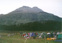
Lake Venado is a place which could have very well been named Eden. It is nestled high on the slopes of Mt. Apo. Located more than 6,000 ft. above sea level and roughly the size of six football fields during the rainy season, it shrinks to about the size of a big pond in the summer. The shores of the lake itself is carpeted with the softest, greenest bermuda grass. A little farther from the lakeshore can be found an abundance of wild berries and "tinikaran" trees, which look like very big bonsais. The summit of mighty Apo itself provides the background to the south. Every now and then a pocket of clouds comes in, blankets the lake area white, and blocks the sun. It then becomes terribly cold and then in a few minutes the sun peeks through again and the warmth is back for a few minutes before another cloud pocket comes and brings in the cold once more. From the lake it takes around 2 to 3 hours of hiking up steep trails through thick cogon fields to the summit. Trekking toward the summit, the "thinning" of the air becomes perceptible and breathing becomes a laborious task. Upon arriving at the summit, the heavy feeling that has been present all day begins to drain and is replaced by euphoria upon reaching the ultimate objective of the climb. 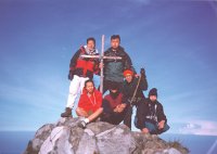
Unlike Himalayan climbs where reaching the summit is just half the challenge and the other half being able to get down alive, getting to reach the summit is pretty much the most difficult part of the climb in Apo. At the summit is a wide saddle mostly used as a campsite. It is bounded by three peaks of which the west peak is the highest. On the east peak is a cross which was erected by religious pilgrims who make regular trips up the mountain as part of their rituals. 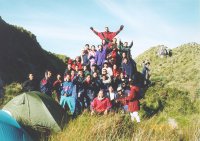
With the clouds rushing down below, one can look all the way out to the sea past lakes and moumtain ranges with deep green forests. In this place, with eyes wide open, one can look deep inside to realize certain truths about oneself and the world we all live in. Thoughts like these have been mostly elusive in the thick and squalid air of urban life. In the mountains what is essential is obvious, what is beautiful is unrelenting, and only what is good endures. |